
A double-headed post this time, as I have an announcement and then I’ll be sharing some of this summer’s walking with you. I’ve decided to start sending out a regular newsletter (some of you have already spotted it, as I added the links to my site earlier in the week–you guys are amazing!). I’ve got a few new releases coming up over the next six months, so expect news, missing scenes (I’m currently writing a little Reawakening extra from Gard’s point of view), and contests. I’m aiming to get this month’s out on the 20th, but after that it will be closer to the 15th of every month.
In less promotional news, my summer is slowly fading to an end. I’ve spent a lot of it editing and writing, but I have had time to fit in a few walks and outings. In particular, Mum and I have been continuing our walk along the Kent coast. We’ve done three walks this summer and managed to cross the Hoo Penisula, which must be one of the most remote places within 40 miles of London. It’s a great bulge of marshland between the River Medway and the Thames but on its far side was our target for the summer: the town of Gravesend and the first possible crossing of the River Thames. In all our coastal walking, our rule has been to cross any river at the first crossing inland, whether that is a ferry or a bridge. We’ve had to walk a long way to reach this one, picking our way around the various inlets and minor rivers of north Kent. The Hoo was the last obstacle, and we were a little nervous about it. Parts of its coast are inaccessible, and the only long distance path that crosses it takes a much more inland route than we wanted. We came up with a compromise, cutting off the tricky corner so we only walked twelve miles of lonely sea wall rather than the twenty-odd we would have needed to do it one day to cover the whole thing.
We began at Rochester, on a grey, muggy, horribly warm day in July.

Looking back across the water towards Rochester, the castle and the cathedral stand out against the skyline. The sub is the U-475 Black Widow, originally Soviet, now in private hands and awaiting restoration. The concrete structure in the foreground is more interesting than it looks. It’s the remains of the lock where a long-vanished canal met the Medway. The Thames and Medway Canal once cut through the back of the Hoo Peninsula, connecting the Medway to the Thames at Gravesend, passing through a 2.2 mile long and 35ft high tunnel at the Medway end. The tunnel took so long to build that the canal didn’t open until 1824, by which time the military need for the connection had vanished with the end of the Napoleonic wars. By 1840, the new railway line to Strood had been laid through the tunnel alongside the canal, and the railway still passes through the tunnel today, although the canal is long gone.
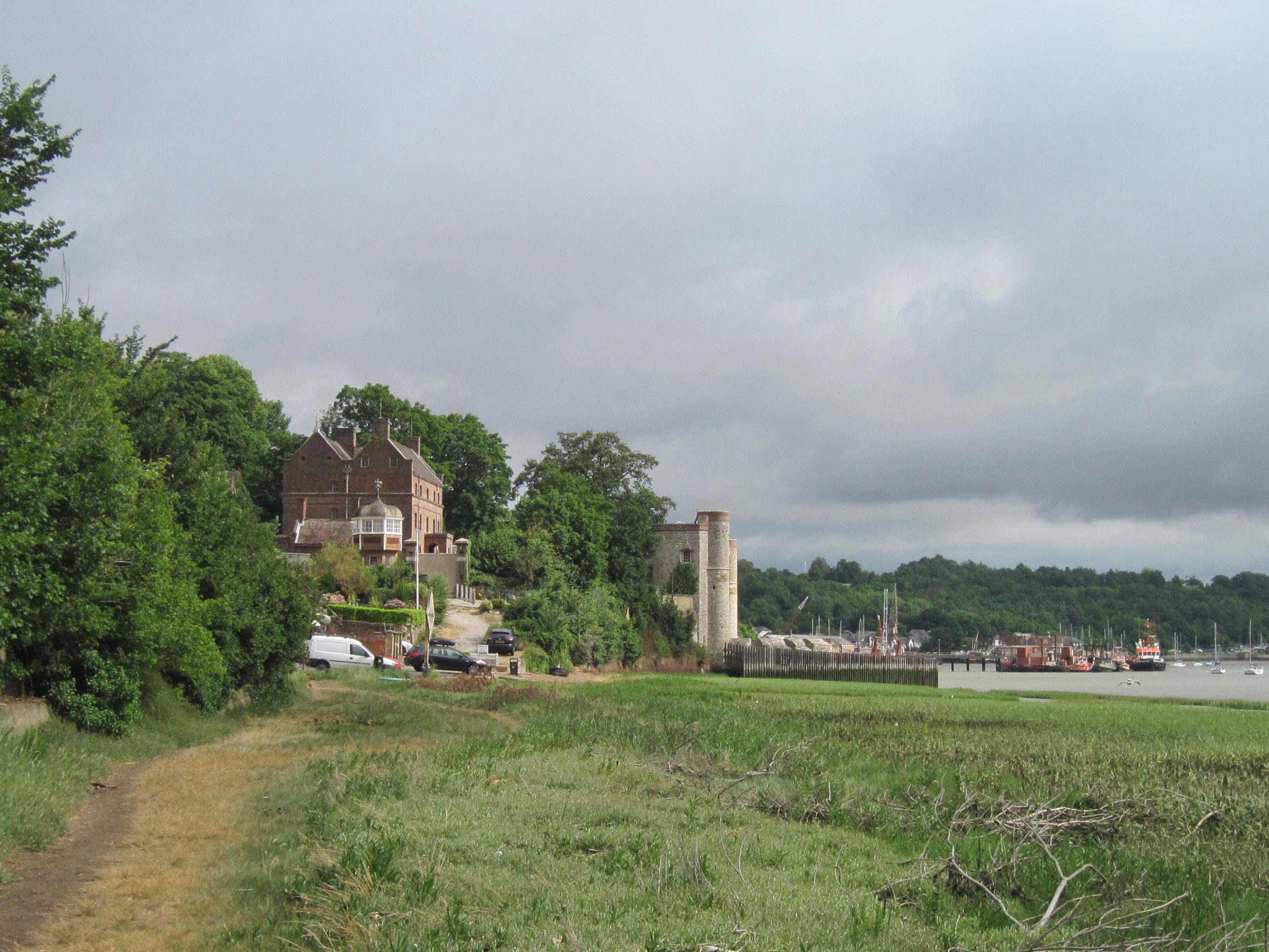
As we walked along the water’s edge, we glimpsed the towers of Upnor Castle ahead of us. The castle is a small fort which was originally built to defend approaches to Chatham Dockyard on the opposite bank. Later, it was used as an ammunition depot. The village grew up around the fort, supporting the navy families living inside the fort.

The gunpowder arrived by boat to the base of the fort, which was roofed in at the time. There are tunnels in the base of the fort but much of it was stored in the main fort. It was lifted by a pulley to a bay several stories up. The pulley was originally operated by men who seized the other end of the rope and jumped from the upper story windows, but that was eventually deemed too risky. Inside the fort, the rooms are designed so that no sparks could be struck by accident: the doors and windows are copper=sheathed, the handrail on the stairs is covered in lead, and the wooden floors were constructed without the use of nails.

You can even get married there, with your guests perched on padded gunpowder barrels.

Upnor High Street is a lshort cobbled street which stretches from here to the edge of the cliff, where the side door to the castle opens straight onto the road.

After leaving Upnor, we walked along the edge of the water, along a path which can only be followed at low tide. We stumbled across this crumbling brick structure, which we guessed might a lime kiln or another military relic.

Offshore were more abandoned wrecks.

Soon though, we left the banks of the River Medway and headed across the farmland that covers the centre of the peninsula. It was very hot once we left the water. We finished our walk at the tiny village of St Mary Hoo, where we had to call a taxi to get back to the nearest station.

We returned to St Mary Hoo three weeks later. The church here is now part of a nursing home. A few years ago, there was a proposal to build a new airport on the Hoo. If it had gone ahead, the church, the village and all the outlying farms and cottages would have been demolished to make way for it. A past rector of the church was the one who performed the illegal marriage between the future King George IV and his mistress Mrs Fitzherbert in 1785.

Following the footpath north, we caught our first glimpse of the Thames. In theory, our path continued onwards to the sea wall, where we would simply follow a path all the way round the edge of the peninsula until we reached Cliffe Creek on the western side.

Numerous climbed gates, paths so overgrown they were invisible, and fences across the path later, we finally made it to the water’s edge, only to find the seawall was only a few inches wide and the path which supposedly ran beside it was impassable. We walked on a track behind the embankment, but soon found that the land was being worked on. Much of it was blocked off with plastic fencing with only small stiles cut out to make it passable. It was several miles until the narrow wall vanished and we could walk along the embankment, but the path was still very overgrown. We knew these paths probably weren’t used much, but we were still taken aback by how tricky they were to follow, given they were supposed to be public rights of way. When we got home, we investigated and couldn’t find anything other than rumours about what was happening. It’s either a huge housing development or a scheme to alter the seawalls to create a water capture area to help manage flooding upstream. Whatever is happening, it seems likely that the paths are doomed.

At the end of the peninsula, tucked into the corner, these huts are part of an old military training area. Although you can’t see them from the path, there are many tiny ponds here which are the flooded remained of WW1 trenches. This was one of the sites where they trained soldiers in trench digging. The nearest road is a couple of miles across the marshes, and there aren’t even official tracks linking the riverbank to the lane. On the water, however, cargo ships go heading into the port at Tilbury on the north bank of the Thames. At this point, we hadn’t seen another soul since leaving the taxi at St Mary Hoo. As we drew closer to Cliffe Creek, however, we began to meet other walkers. We swung inland between defunct and flooded gravel pits, now a nature reserve, until we reached the village of Cliffe. It’s a strange little place. It was founded by the Romans, once supported several industries, has one of the the biggest local churches in Kent, was a medieval port, and once had a branch line and a canal. Dickens set the start of Great Expectations here. Today, it’s very quiet. There’s one local shop on the outskirts, a single pub, and a bus three times a day. Even the lights in the public loos at the bus stop don’t work. We were in time for the last bus back to Gravesend, which wound its way in loops all over the Hoo.

We returned to Cliffe a week later to walk the last few miles from the edge of the Hoo to the ferry at Gravesend. This is Cliffe Creek at low tide, with a slightly wreck from some of the others we’ve seen, and Mum and I spent some time speculating about this one.

Unfortunately our easy walk then got tricky as we discovered the path was closed because it had subsided and we had to take a very long detour away from the water, through a farm and along a very long path which went right through the middle of a huge gravel works before we finally got onto the embankment.

We didn’t see many people, but we did have some company on our path.

Very suddenly the wilderness gave way to the industrial outskirts of Gravesend. Within a few hundred metres of this area, we crossed the opposite end of the old Thames and Medway canal and found ourselves in a park in the centre of town.

By now the tide was high and we had to wait for this ship to pass before our boat could cross the river. This one is on its way to Zeebrugge. It was being followed out by a pilot ship waiting to take their pilot offboard once the ship reached the sea.

This, however, was our ferry. It chugs back and forth between Gravesend and Tilbury on the north bank. We went across, because it was there, and then came straight back again.

We then headed back into Gravesend. We were impressed by the extensive yarnbombing (the knitted seagulls on the pier were great too).

Gravesend is also the burial place of Pocohontas. She was taken ill on ship on her way back to the New World and brought ashore at Gravesend for medical attention (a grim prospect in 1617). Sadly, she died here, aged no more than 22. The exact location of her grave is unknown, but this memorial stands in the churchyard.
